

31st March -
 We head north to the Bay of Islands going through New Zealand’s only toll road on
the way. In Australia and NZ the toll booths on the toll roads have been closed and
it’s up to you to notice that you’ve been on a toll road and logon to the relevant
website to pay afterwards, a bit like the London Congestion Zone. In Australia we
had to pay three different websites, in NZ it is different as the camper company
have got an account that automatically pays the fees and then you pay them at the
end. This is easier but we only find out after an unsuccessful attempt to pay the
tolls ourselves.
We head north to the Bay of Islands going through New Zealand’s only toll road on
the way. In Australia and NZ the toll booths on the toll roads have been closed and
it’s up to you to notice that you’ve been on a toll road and logon to the relevant
website to pay afterwards, a bit like the London Congestion Zone. In Australia we
had to pay three different websites, in NZ it is different as the camper company
have got an account that automatically pays the fees and then you pay them at the
end. This is easier but we only find out after an unsuccessful attempt to pay the
tolls ourselves.
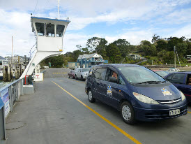
We miss the turning for Russell and end up taking the ferry. Luckily it only costs $12 (£7) for the two of us and the car and is actually a lot quicker than taking the land route. Russell, ancient capital of New Zealand, is tiny. The capital moved because Maoris kept on chopping down the signal flagstaff used for communication across the bay. We went to see the flagstaff and, even though no attempt has been made to chop it down recently, they're taking no chances as the bottom section is cased in a concrete filled metal tube.
2nd April -
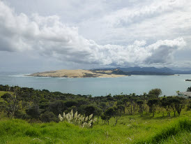 Leaving Russell we head north to the bottom end of 90 mile beach which runs the full
length of the thin top end of New Zealand. Mad Mike, the Fraser Island 4WD bus driver,
told us that 75 mile beach (not quite 75 miles long) on Fraser Island was the longest
in the world; the only beach used as a highway in the world and one of only two beaches
used as a runway. The runway claim seems to be the only one that was true as 90 mile
beach (not quite 90 miles long) is longer and is also used as a highway.
Leaving Russell we head north to the bottom end of 90 mile beach which runs the full
length of the thin top end of New Zealand. Mad Mike, the Fraser Island 4WD bus driver,
told us that 75 mile beach (not quite 75 miles long) on Fraser Island was the longest
in the world; the only beach used as a highway in the world and one of only two beaches
used as a runway. The runway claim seems to be the only one that was true as 90 mile
beach (not quite 90 miles long) is longer and is also used as a highway.
After taking a photo of 90 mile beach (which our rental agreement specifically forbids
us from using) we arrive at Kaitaia tourist information without a clue of where to
go next. The no-
We stay for a couple of days, visiting some strange spherical boulders on a beach
and a waterfall near a wooden puzzle museum run by a couple of hippies. They tell
us that they are getting an elephant from Auckland zoo and the level of detail supplied
eventually gets you believing that they are. In fact it turns out that the elephant
is a full-
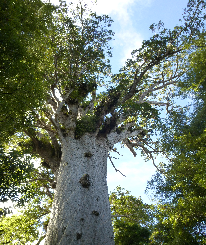 In the evening we go on a Maori twilight walk to see the largest Kauri trees in the
world in a nearby forest. Bill is a good guide, he used to be a welder on the metal
skeletons of Auckland skyscrapers and his heavy boots mean that he sounds like a
giant when he walks. We tell him enough detail about the elephant to keep the deception
going (he remembered that he had already heard about it but had just dismissed it
as impossible -
In the evening we go on a Maori twilight walk to see the largest Kauri trees in the
world in a nearby forest. Bill is a good guide, he used to be a welder on the metal
skeletons of Auckland skyscrapers and his heavy boots mean that he sounds like a
giant when he walks. We tell him enough detail about the elephant to keep the deception
going (he remembered that he had already heard about it but had just dismissed it
as impossible -
The next day we stop to see the largest Kauri (pronounced cody) tree, Tane Mahuta, in the daylight. The largest trees are two to three thousand years old and the top of them contains a small forest with 28 different species of tree and plant that are growing in the tree’s nooks and crannies.
3rd April -
On the move again: just because its Karen’s birthday doesn’t mean we can rest and relax. Karen is, on this basis, extending her birthday to last a few days...
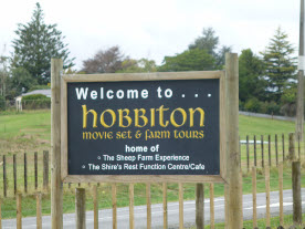 Matamata is the closest town to Hobbiton, the now permanent Lord of the Rings film
set. A temporary set was created for the first LOTR film and then largely removed.
For the films of The Hobbit (how do you get three films out of one small book?) the
set was made permanent and cost $65m as a result (“How much!?” I hear you ask. We’re
not sure where all the money went either but they did spend $500k on a full size,
completely artificial oak tree).
Matamata is the closest town to Hobbiton, the now permanent Lord of the Rings film
set. A temporary set was created for the first LOTR film and then largely removed.
For the films of The Hobbit (how do you get three films out of one small book?) the
set was made permanent and cost $65m as a result (“How much!?” I hear you ask. We’re
not sure where all the money went either but they did spend $500k on a full size,
completely artificial oak tree).
After the film set tour we head for the glow worm caves at Waitomo. The caves have a river flowing through them and thousands of glow worms live in the roof, dangling short sticky ‘fishing lines’ to catch unwary insects attracted to their blue glow in the black darkness of the cave. Seeing all of the blue dots of light above you was quite eerie but, as no photographs were allowed, you’ll have to take our word for it.
The number of entries to the ‘Song for Karen’ competition was small but the quality was high as the video for The Blog Song by Jude and Gary shows:
5th April -
Rotorua is the home of NZ tourism with people coming to take the ‘cure’ since the early days of western settlers. It has been popular with the Maoris for longer than that as the geothermal activity just under the surface keeps you warm in the winter and some of the hot pools are suitable for cooking. Everywhere you look you see clouds of steam coming out of the ground and, as someone we met had told us: “Rotorua stinks”. Because of its relative glitz compared with the rest of the country Rotorua has been dubbed Rotovegas, presumably by someone who has never been to Las Vegas, and RotoVegas is also the name of the motel we stay in. Virtually every place to stay has naturally heated water that you can fill your own spa bath with and ours in no different but it is half outside and the coldish weather puts us off trying it, or was it the plastic pink flamingo?
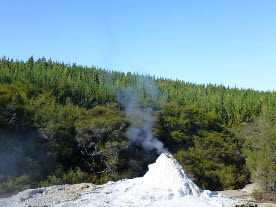 We visit the Lady Knox geyser which goes off at 10:15 each morning, much more reliable
than even Old Faithful in Yellowstone national park. How on earth is this precise
timing achieved and how does the geyser know when the clocks have changed? The answer
is that the geyser is induced by having a bag of soap dropped into it. They argue
that there is nothing unnatural about this and it would have gone off sometime later
in the day anyway. They also say that the eruption lasts between two minutes and
two hours, it struggled to reach two minutes when we saw it but was still reasonably
spectacular while it was going (it is resting in the photo on the left). The reason
that the geyser doesn’t have a Maori name is that the Maoris didn’t know it was there.
It was discovered in 1901 by the inmates of the local low security prison who tried
to wash some clothes with dramatic effect. After walking around a number of other
sulphur lakes, craters and rock formations we head for Rotorua’s Skyline to go up
in a gondola and come down on a luge. We didn’t realise that the luge doesn’t go
right to the bottom so you have to go back to the top on a ski lift before coming
back down in the gondola. The ski lift is by far the most exhilarating/scary experience
of the day.
We visit the Lady Knox geyser which goes off at 10:15 each morning, much more reliable
than even Old Faithful in Yellowstone national park. How on earth is this precise
timing achieved and how does the geyser know when the clocks have changed? The answer
is that the geyser is induced by having a bag of soap dropped into it. They argue
that there is nothing unnatural about this and it would have gone off sometime later
in the day anyway. They also say that the eruption lasts between two minutes and
two hours, it struggled to reach two minutes when we saw it but was still reasonably
spectacular while it was going (it is resting in the photo on the left). The reason
that the geyser doesn’t have a Maori name is that the Maoris didn’t know it was there.
It was discovered in 1901 by the inmates of the local low security prison who tried
to wash some clothes with dramatic effect. After walking around a number of other
sulphur lakes, craters and rock formations we head for Rotorua’s Skyline to go up
in a gondola and come down on a luge. We didn’t realise that the luge doesn’t go
right to the bottom so you have to go back to the top on a ski lift before coming
back down in the gondola. The ski lift is by far the most exhilarating/scary experience
of the day.
Karen had an anti-
7th April -
And now to Napier, the art deco capital of NZ. Entirely rebuilt in deco style in the 30s after an earthquake flattened it. A lot of the buildings still exist although many of the facades have been spoilt by the addition of verandas over the pavement in the 60s and 70s. We get an excellent room thanks to a neighbouring guest who has parked their large car so close to the door of our original room that access isn’t possible.
We spend one morning walking up to Te Mata Peak near Havelock North (‘North’ to distinguish from Havelock on the south island), and made the walk much longer by misunderstanding the instructions and walking from the town centre rather than the car park near the top. Stopped at a great foodie shop afterwards for supplies for tea then popped into Church Road winery on the way back to Napier for a tasting and a bottle to go with our gourmet food.
8th April -
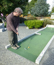 Stopped at Masterton for chips and a round of crazy golf. Karen tried kumara chips
(made from NZ sweet potatoes -
Stopped at Masterton for chips and a round of crazy golf. Karen tried kumara chips
(made from NZ sweet potatoes -
On our way again we see a sign for Aotearoa Stonehenge (Aotearoa is the Maori name
for New Zealand and means land of the long white cloud). We divert to have a look.
A farmer has made a full-
Martinborough is a nice town, much better than those we’ve driven through on the
way down, Our hotel is lovely but dinner there is disappointing so we head to the
cafe over the road for our ‘vintner’s breakfast’ (meat-